Objective of the chapter: The Globe - A Model of the Earth (Class 5)
You will learn about:
- The shape of the Earth
- The Globe as a small model of the Earth
- The North Pole and the South Pole
- Latitudes and Longitudes
The Shape of the Earth
Long ago, people believe that the Earth was flat. They believe that if anyone travel to the edge of the Earth, he or she would fall off.
However, the shape of the Earth is round, not flat.
If you look around you will also feel the Earth is flat. It appear flat to us because it is so much bigger than us.
At a time, we can only see short distances.
You may ask, how can we see that the Earth is actually round in shape.
To see the round shape of the Earth, you would need to go high into the sky. At such height you can see the curving surface of the earth, not the edges.
Astronauts who goes into the space can see the round surface of the Earth.
The large size of the Earth makes it very difficult to study it as a whole. To overcome this difficulty, Geographers has developed different means to represent Earth on a much smaller scale to make its study easy.
Though there are many such tools for this purpose but the most important and widely used tools are globes and maps.
The Globe
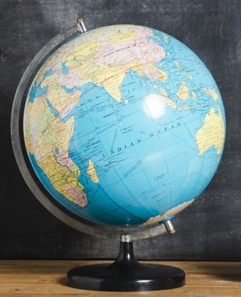
A globe is a small spherical model of Earth. It is mounted on an axle that permits rotation.

See the above image. It is a globe. On a globe, we can see the shape and location of the continents and oceans on a smaller scale.
It also shows the shape and location of all the countries and important cities of the world.
We can only see one-half of the globe at one time. To see the other half we can rotate the globe.
The globe is mounted on an axle that permits rotation. This axle is called the axis. It is not straight. It is tilted at an angle of 23 and 1/2 degree.
The axis of the Earth is also tilted at an angle of 23 and 1/2 degree to the verticle.
The Earth constantly rotates around its axis which causes day and night on Earth.
The axis of rotation of the globe is similar to that of the Earth.
Northern and Southern Hemisphere
So far, you learn what is a globe. You also learn that both the globe and the Earth rotates around its axis.
The two end points of the axis of rotation are called the poles. The pole to the north is called the North Pole, and the pole to the south is called the South Pole.
Midway between the North Pole and the South Pole is an imaginary line circling the Earth. It is called the Equator.
Equator divides the Earth into two equal halves, called the hemispheres.
To the north of the Equator is the Northern Hemisphere, and to the south of the Equator is the Southern Hemisphere.
Latitudes and Longitudes
Horizontal and vertical lines are drawn on a globe to locate places on it.
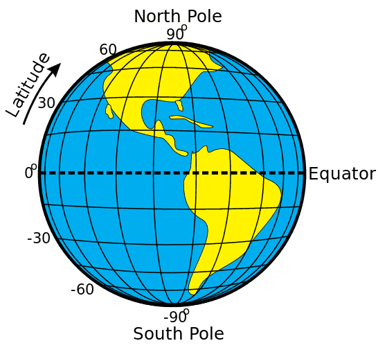
The horizontal lines are parallel to the Equator. Like the Equator, they go around the Earth. These lines are called latitudes or parallels.
The vertical lines are semicircles that run from the North Pole to the South Pole. They are called longitudes or meridians.
Latitudes and longitudes are marked in degrees (°) and minutes (').
Sixty minutes equal one degree (60' = 1°).
How Latitudes are marked?
The equator is marked 0°. The North Pole is 90° North, and the South Pole is 90° South. Thus, the latitude of a place tells you how far north or south a place is from the Equator.
For example, a place with a latitude of 45° North is located in the Northern Hemisphere, midway between the Equator and the North Pole.
A place with a latitude of 60° North is further North.
There are 180 degrees of latitude in all. There are 90 degrees of latitude in the Northern Hemisphere and 90 degrees of latitude in the Southern Hemisphere.
Features of Latitudes

Lines of latitude. Image: Djexplo – Wikimedia Commons, CC BY 2.0
- Latitudes are parallel to the Equator. Equator and Poles are also latitudes.
- They run parallel to each other in the east-west direction.
- They are at an equal distance from each other.
- All of them form complete circles, except the North and South Poles, which are points.
- The latitudes decrease in length as you move from the equator to the poles.
Other Important Latitudes
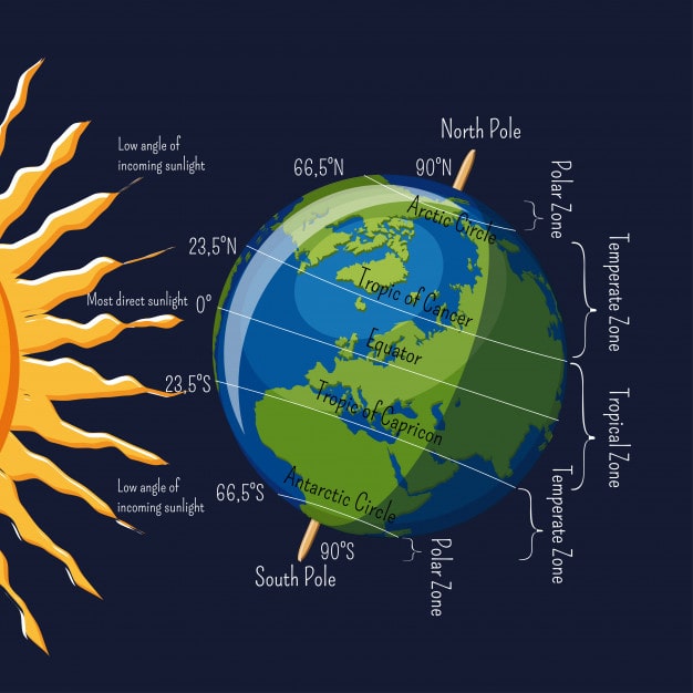
Five important parallels of latitudes are:
- Artic Circle at 66 and 1/2° North
- Tropic of Cancer at 23 and 1/2° North
- Equator at 0°
- Tropic of Capricorn at 23 and 1/2° South
- Antarctic Circle at 66 and 1/2° South

Important Latitudes
How Longitudes are marked?
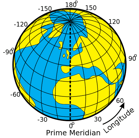
Longitude is measured by imaginary lines that run around the Earth vertically (up and down) and meet at the North and South Poles. These lines are known as meridians.
The longitude running through the old Royal Observatory at Greenwich near London is marked 0°. It is called the Greenwich Meridian or the Prime Meridian.
There are 360 degrees of longitude - 180° of longitude east of the Prime Meridian, and 180° of longitude west of the Prime Meridian. The 180° East and 180° West longtitudes meet and form a single line on the opposite side of the world, called the 180° longitude or the International Date Line.
Thus, the longitude of a place tells how much east or west of the Greenwich Meridian the place is located.
Features of Longitudes

Lines of longitude. Image: Djexplo – Wikimedia Commons, CC BY 2.0
- Longitudes are semi-circles that run from one pole to the other pole.
- They run in north-south direction.
- Longitudes are spaced farthest apart at the Equator and come together to a point at the poles.
- The latitudes and longitudes cut each other at right angles.
- A degree of longitude is about 111 kilometers (69 miles) at its widest.
The Global Grid
Longitude is related to latitude. Globes or maps are often marked with parallels and meridians forming a network of lines, creating a grid. This is known as the global grid.
The point in the grid where parallels and meridians intersect is called a coordinate. Coordinates can be used to locate any point accurately on Earth.
Recap Of The Chapter: The Globe - A Model of the Earth (Class 5)
- The Earth is round in shape.
- A globe is a small model of the Earth.
- We can see the shape and location of the continents, countries, cities, oceans and seas on a smaller scale on a globe.
- The Equator is an imaginary line that divides the Earth into two equal halves called the hemispheres.
- Latitudes are horizontal lines drawn on a globe that go round the Earth. They are parallel to the Equator.
- Longitudes are vertical lines drawn on a globe that run from the North Pole to the South Pole.
- If we know the latitude and longitude of a place, we can locate it accurately on the global grid.
Exercises
A. Fill in the blanks.
- The Earth rotates along an imaginary line called the ___________.
- The Earth is divided into two hemispheres along an imaginary line called the __________.
- __________ are lines that run parallel to the Equator.
- On a globe, the lines running between the two poles are called _________.
- The latitude marked 23 1/2° South is known as the _________ of ________.
- The meridian marked 0° is called the __________ Meridian.
- Axis
- Equator
- Latitudes
- Longitudes
- Prime
B. Multiple Choice Questions.
- Which of these is an imaginary line?
(a) Equator (b) Longitude (c) Latitude (d) All of these - Which of these pertains to the North Pole?
(a) 90° N (b) 0° N (c) 180° N (d) 180° S - Which of these lies in the Southern Hemisphere?
(a) Tropic of Cancer (b) Arctic Circle (c) Tropic of Capricorn (d) All of these - The longitude of a place tells us
(a) how far north or south a place is from the Equator
(b) how far east or west a place is from the Equator
(c) how far north or south a place is from the Prime Meridian
(d) how far east or west a place is from the Prime Meridian - The longest latitude is the:
(a) Tropic of Cancer (b) Tropic of Capricorn (c) Equator (d) They are all equal - The longest longitude is:
(a) the Prime Meridian (b) 180° East (c) 90° West (d) They are all equal
- All of these
- 90° N
- Tropic of Capricorn
- how far east or west a place is from the Prime Meridian
- Equator
- They are all equal
C. Match the columns.
- Arctic Circle a. 23 1/2° N
- Antarctic Circle b. 66 1/2° N
- Tropic of Cancer c. 0° meridian
- Greenwich d. 66 1/2° S
1. - b.
2. - d.
3. - a.
4. - c.

This is very imformative and i am enjoying it. It is very fun and it will help for my exams a lot. It is not difficult to do it. And it is really nice ,fun and informative. I like who you make us do the exercises. And I think it is very nice. 😀👩🏫 thank you 😊